

Creating a Large Wall Map Using QGIS Print Layouts
This presentation provides an overview of using the Print Layouts function in QGIS. For this presentation I am using QGIS Version 3.28

The VerticalGeo UAS Mapping Portal
Today we go public with VerticalGeo's latest offer in providing UAS (Drone) Pilots ways to add enormous capability while lowering operating costs. We are introducing the VerticalGeo UAS Mapping Portal. We provide very similar capability to DroneDeploy and Pix4D at a fraction of the price. Please check out the presentation to learn more. Contact us via E-Mail at rick.marshall@verticalgeo.com if you would like a demo of the Portal.

FAA Webinar on “How METARs Are Made”
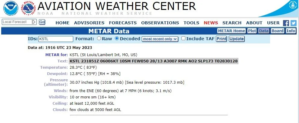
Join us for A VIRTUAL cup of coffee, a donut, and a LIVE WEBINAR as Fred Remer discusses how Meteorological Aerodrome Reports (METARs) are created. Fred is a weather observer at KGFK, Grand Forks International Airport along with being a professor of meteorology at the University of North Dakota. Learn how weather observations are made, and how they are translated into the METARs we use in our daily flying. The webinar is hosted by the FAA on Saturday June 3 at 9:00am Central Time. You can register for the webinar here.
Using QGIS to Collect and Map Road Networks in the Caribbean
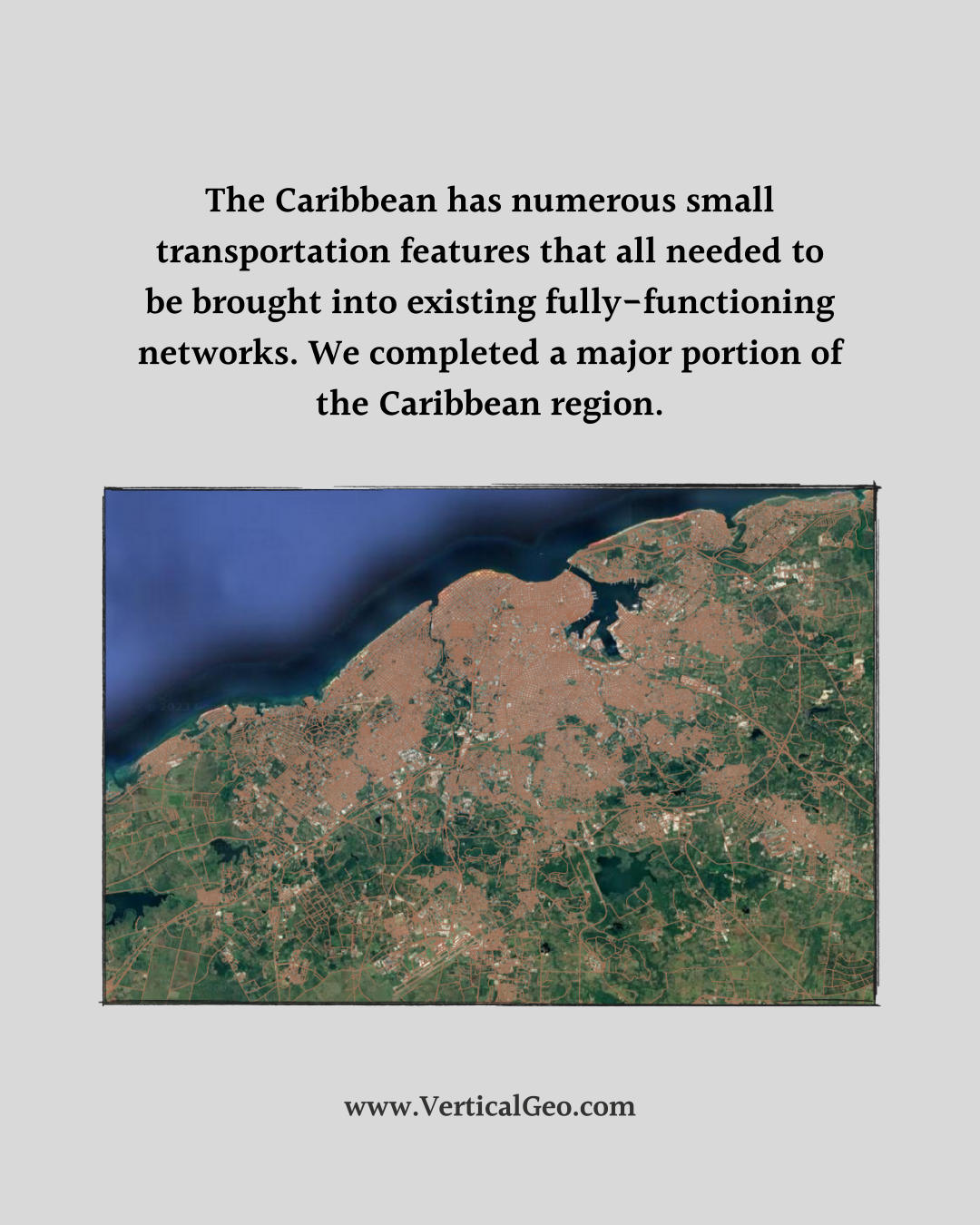
This is a project we worked on a couple of summers ago. We decided to use this project as a training program for our company to learn how do large scale data collection and mapping using open source and free QGIS software. We believe we did our best quality work and produced the road network faster using open source QGIS than we could have with our more expensive ESRI ArcMap software.
Rather than spending all of your budget on expensive GIS software we highly encourage you to try out QGIS to see if your organization could benefit from using open-source software and investing the money you save into collecting and maintaining top quality data. Not sure where to start? Send us a message and we can help you with a solution that works for your organization. Invest in data, not software!


VerticalGeo FAA Part 107 Prep Course
Introducing the new all-online VerticalGeo UAS Academy - Part 107 Test Prep Course! This Course may be for you
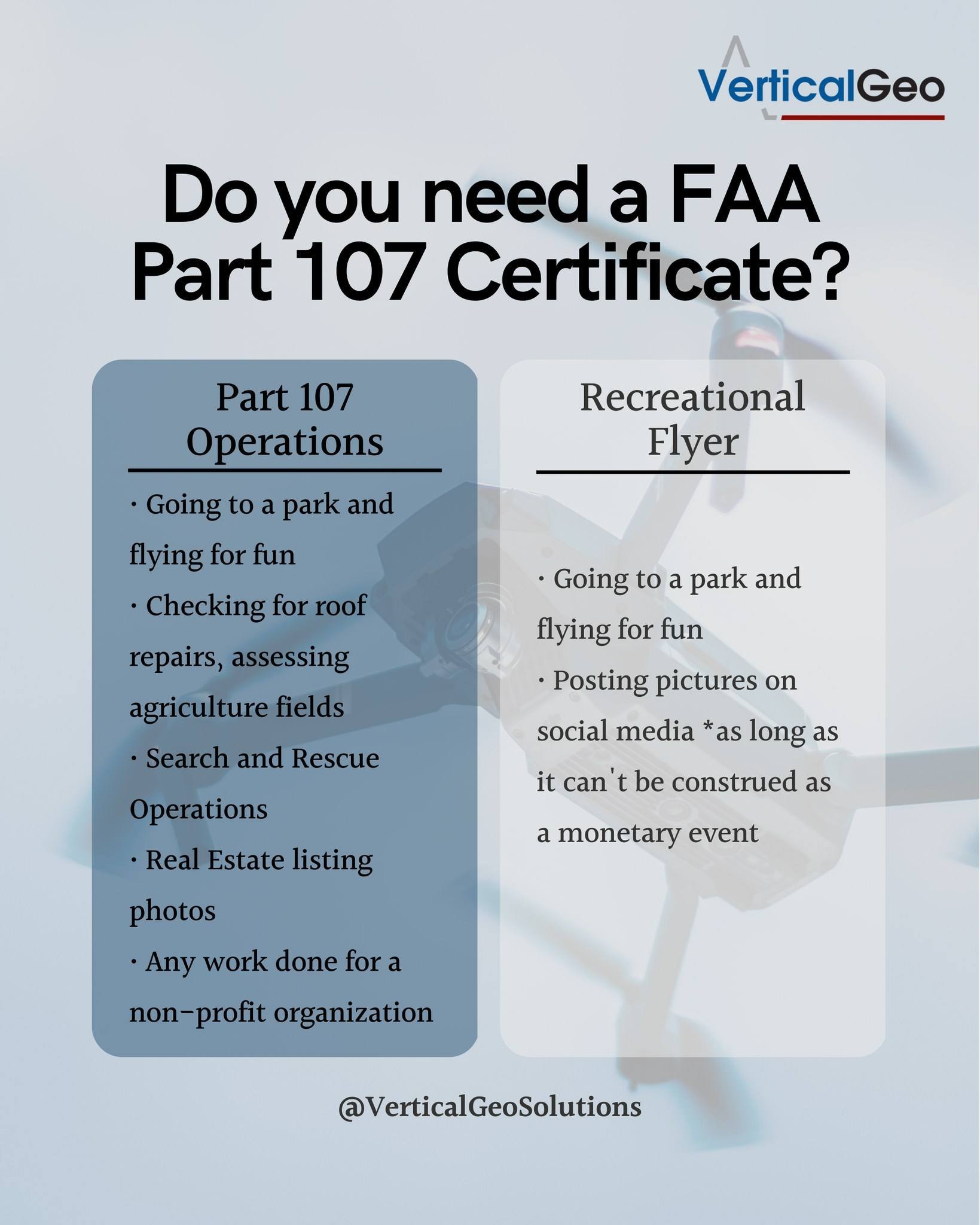
Are you currently a Recreational UAS (Drone) Pilot?
Are you taking photos or videos at the request of another person or a business?
Do you want to start making money providing UAS (drone) services?
If you answered yes to any of the questions above, this course is definitely for you! If you are flying your UAS for non-recreational purposes, you might be increasing the risk of liability issues if you have an accident.
If you are unsure about whether or not the reason you are flying your UAS requires Part 107 Certification, leave a comment on our FaceBook Post and we will be happy to get back with you.
Use the link below to find the new VerticalGeo UAS Academy - Part 107 Test Prep Course. Our course is inexpensive, online, on-demand, and you can easily complete it on your own time. It will definitely provide you with ease of mind to know what you are doing is legally defensible and prep you for the FAA Part 107 Exam.


Developing an Online, On Demand, FAA Part 107 UAS Certification Course
VerticalGeo created an in-person FAA Part 107 UAS (Commercial Drone Pilot) course and we took it on the road last fall to teach First Responders. It was a big success. We helped teach the First Responder community how to become more standardized and operate more safely in a very challenging environment. Many First Responders are already using a UAS in search and rescue and in other operations and the FAA has given them the option of using Part 107 procedures or developing their own standard to cover UAS operations. For liability and standardization purposes First Responders need firm procedures to follow when using a UAS. We developed our FAA Part 107 Certification Course to give them a framework to work within.
With the foundations we provided in the First Responders class we have developed an online, on-demand Part 107 Certification course to make the FAA UAS certification more accessible to a larger group of aviators. We have designed a course to take an individual or a group of individuals who are interested in becoming a FAA Certified UAS Pilot and teach them the rules, regulations, safety concerns, and knowledge that will get them certified. We believe we will have the course completed and published in the next two weeks.
A course is easy to offer online, but what is more difficult is to create an online community centered around the FAA Part 107 Certification where we can raise awareness of UAS capabilities, provide information to UAS enthusiasts, form a chat-based help desk, host online meetups, and foster community engagement to discuss current FAA Part 107 regulations.
We will have more details on our course as we get it ready to publish it, but it should be very comprehensive and worth the investment in resources we have dedicated to it to try to create a new community.


Teaching a FAA Part 107 UAS (Drone) Certification Course to First Responders
VerticalGeo had the honor of teaching a FAA Part 107 UAS (Drone) Pilot Certification Course to First Responders in Effingham County, Georgia October 24-28, 2022. We spent 4 days teaching academics and leading the First Responders through Hands-On flying experience with small drones. We capped off the course with an end of course Search and Rescue exercise where we helped the First Responders use drones to locate a missing family with an injured family member.
Our course included 20 hours of academics and 10 hours of Hands-On drone familiarization training. We also provided each student with a copy of the training documentation, which included several hundred FAA Part 107 Exam Practice Questions.

Part 107 Certification Course Academics
Public entities, including municipalities can choose to fall under the Part 107 regulation, but they are not required to. It is up to them to determine if they want to fall under the FAA Part 107 Certification guidelines or to work with the FAA to create their own Certificate of Authorization (COA) to operate as a Public Aircraft Operator (PAO) and implement their own FAA approved program to train public employees to use drone technology in Public Works, Emergency Management Services, Parks and Recreation, Assessors Offices, and other departments. For many municipalities and counties, choosing go the Part 107 Certification route is the easier option. We provided the Effingham County, Georgia, Emergency Management Services branch with a course that covered a detailed overview of all topics within the FAA Part 107 Certification Program and ensured the students understood both what is on the Part 107 Certification Exam and how to use the information in the field after they complete the test. When we complete the course all students have the information needed to pass the FAA Part 107 Certification Exam .

Hands-On Flight Training with the Drone
As mentioned earlier, we completed the week of training off with an in-the-field search and rescue exercise that helped the First Responders understand how to use drones to aid in the search for a missing person or persons. The pressure filled exercise environment helped bring some realistic experience to the end of the course.

Search and Rescue exercise to cap off the Part 107 Training Week
The FAA allowing public entities to choose to either use Part 107 regulations or develop their own regulations brings some opportunities for public entities to create their own Drone certification program for their employees that reflects their unique requirements and capabilities. If you would like the Part 107 Certification Course to be taught to your employees (public or private), or if you would like a consultant to help you develop your own drone certification program we would be happy to help.
We taught the Part 107 Certification Course two weeks ago and the Monday after we completed the course one of the Effingham County First Responders took the FAA Part 107 Exam at a testing center and passed with flying colors. We enjoyed creating and teaching this course and look forward to more in the future

Our Students from the First Responders Course
Moving from a Physical Server to the Microsoft Azure Cloud
We have spent most of the past 3 months working to move our operations from our own physical server to the Microsoft Azure Cloud. There are lots of cloud-based storage systems out thee and we decided to try Azure. We were able to do this easily with our file-based systems, but it has proven to be a lot of work to convert our PostGreSql GeoDatabase over to the cloud. We have learned a lot, and we are better for it. Here are the benefits of having a cloud based storage and server system:
Our employees can now access our GeoDatabase, and provide data collection services, from anywhere they have internet service. We have sold our building that we bought 5 years ago and are transitioning to a remote work environment, saving all of us commuting time and the expense of gas for the commute. Employees can now work from home and enjoy the time and gas savings of not having to commute to the office.
Selling our building will dramatically reduce our overhead expenses, helping us to compete for business in an economically competitive environment. The Azure solution will cost us money every month, but without the overhead of maintaining the building we will be far ahead.
The move to the cloud will help us accomplish some research and development projects that were only dreams before. Being able to connect remotely to our data and virtual machines will help us be connected in the field. With the addition of some appropriate technology we can be connected in the field anywhere.
The research and development experiments that we can now accomplish will help open up new markets for us. We have been brainstorming new technologies and how to use them to push our current technology forward and we are excited to see where this can take us.
We will be able to grow in our knowledge of networking technology and keep on the leading edge.
The next couple of weeks will be very difficult for us as we get accustomed to the new processes.


Boundary Monument Rehabilitation at Table Rock Lake
We are finishing up a great project where we are rehabilitating the US Army Corps of Engineers property boundary at Table Rock Lake, just north of Branson, Missouri. Our task from the Corps of Engineers has been to locate 439 boundary monuments that define the Corps of Engineers property boundary on one of the northern fingers of Table Rock Lake. If we find the boundary monument we record its information and condition, and if it is missing we reset a new one and record its information. We also have to cut a 2 foot path of cleared brush along the property line. We have had 2 survey crews out at Table Rock Lake on 10 day trips for the last 3 months, and we have just finished the field work portion of the task
It has been very challenging task because although some of this boundary has been resurveyed in 2016, most of it has not been resurveyed or the brush cleared out since the 1970s. So, no one has maintained the property line in about 50 years. It has been a lot of hard work in some very difficult terrain. But, it has also been in an incredibly beautiful location. The area of Table Rock Lake we have been working in is about a 30 minute drive from Branson in the beautiful Missouri Ozarks. Here is what a boundary monument looks like. You can see that this one is brass and it was stamped in the center with the year 1973. So, it has been there for nearly 50 years. When we can’t find one and reset the monument we place an aluminum one that will last almost forever.

Most of the monuments are marked by a white T-Post and circled with a white painted collar of rocks. You can see both of these below and get an idea of what the terrain looks like that we have to clear a 2 foot path through between this monument and the next one. You can see the other team member in the distance wearing the bright yellow shirt just beyond the orange blaze mark on the tree. He is using a chainsaw to chop down a small tree that has grown in the 2 foot path of the property boundary. This was a fairly flat part of the boundary line. The next boundary monument is beyond our other team member by several hundred feet.

Here is a static screensshot of an interactive map that we put together to show where all the monuments were located that we were rehabilitating. If you click on the screenshot it will take you to the interactive map where you can pan across the map looking at any feature you want, and you can zoom in and out. If you click on any of the dots, which represent the boundary monuments, it will bring up all the data we collected for each of the monuments we located or reset.

So far it has been a fun project, but there is still about a month’s worth of work to do on it back in the office. Now that the weather is turning colder and snow will begin falling it is nice to be working indoors again!

An Alternative to the Collector App
We have a customer who we have helped perform geospatial data collection projects for the past few years. Their business has grown substantially this spring and they will be very busy this summer. The past few years we have been helping them use ESRI’s Collector App and syncing their data with ArcGIS Online. They are at their maximum limit of named users with their ArcGIS Online account and with their new business they are looking at adding about 12 new named users. ESRI is now charging $500 per new named user per year. So, in addition to what the currently pay for their basic 10 named user accounts ESRI wants to charge them another $6,000 to add 12 new accounts. You can see how this gets expensive quickly.
To help our customer out we have been researching alternatives to the Collector App. We have been looking for Open Source software that is either inexpensive or free to satisfy our customer’s needs. In addition to cost, we are looking for more freedom in licensing options using Open Source Software. We have been using QGIS more frequently the last couple of years and we think we have found a possible Open Source software solution for our customer using QGIS as the backbone of their system.
We are doing field testing of the Input App paired with Mergin that will allow it to sync up with QGIS desktop to provide a map of the data collected through the Input App. We believe using this workflow we can create shapefiles we can then visualize on the web via our VerticalGeo web mapping portal that runs on GeoNode. That way we can provide them with an end to end Open Source Software solution that will be less expensive, more freely available, and customizable to their needs.
The process of collecting and displaying field geospatial data seems a bit more complicated using this process than using the Collector App and ArcGIS Online, but ESRI continues to find more ways to over charge their customers for software use and the licensing restrictions are getting more and more difficult for us to navigate around. Plus when you contact ESRI and ask them about how they charge for ArcGis Online and their credit system that users purchase no one at ESRI seems to be able to give us a good answer on how the credit system works. It seems like they are making up the charging process as they go along. It is too expensive and I am not sold on the ArcGIS Online product look and feel.
We are just getting started with GeoNode and are new at using the software. Here is an example we have done recently with displaying data on our web mapping portal. In this instance it was our surveying task at Greers Ferry lake, near Heber Springs, Arkansas. Please feel welcome to click on the map below. It will take you to the live map on our mapping portal where you can test drive GeoNode. We are still new at using GeoNode and hope to have a better selection of maps hosted on our portal in the near future.

Checking Ground Control at Carlyle Lake State Fish and Wildlife Area
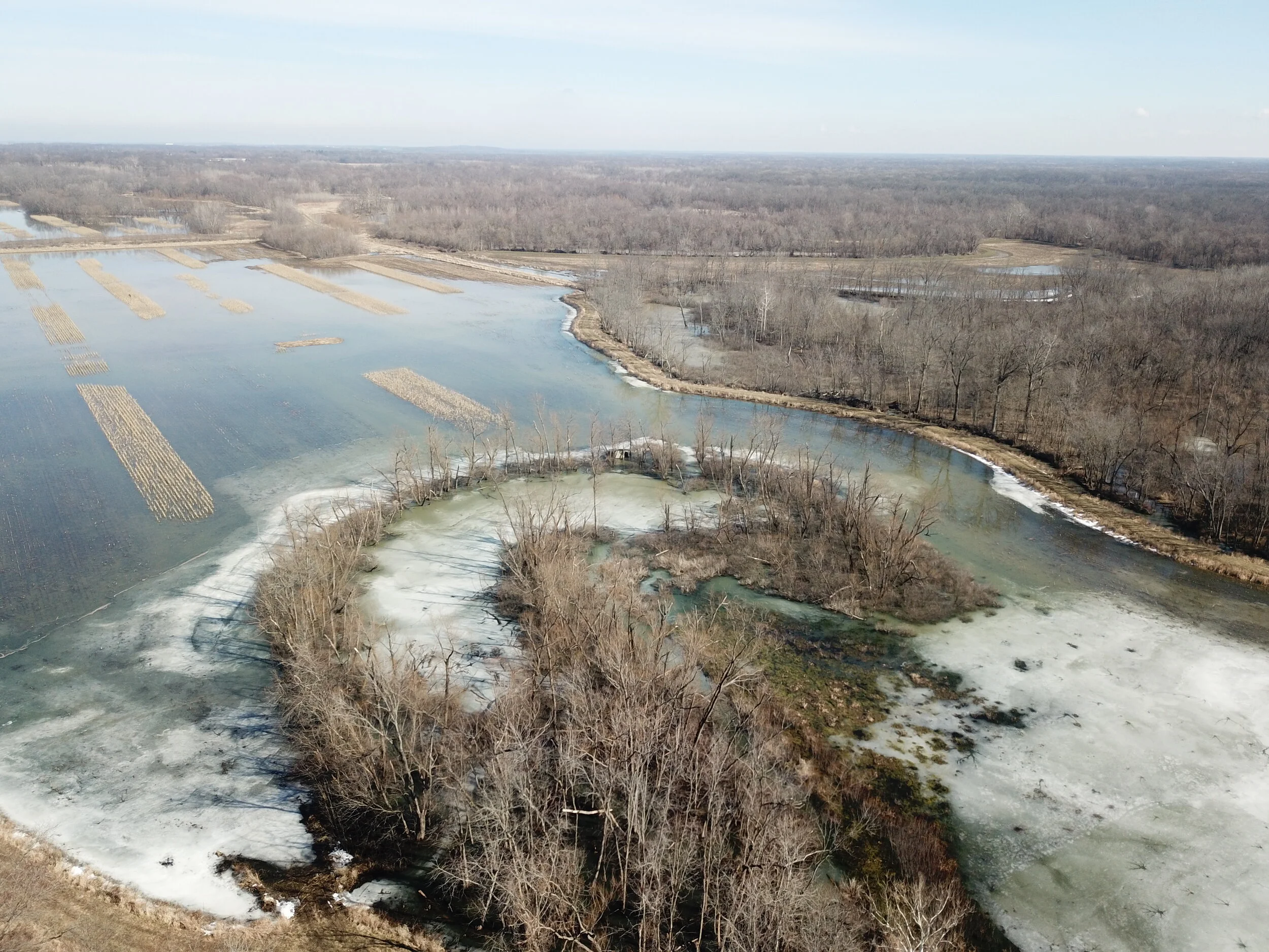
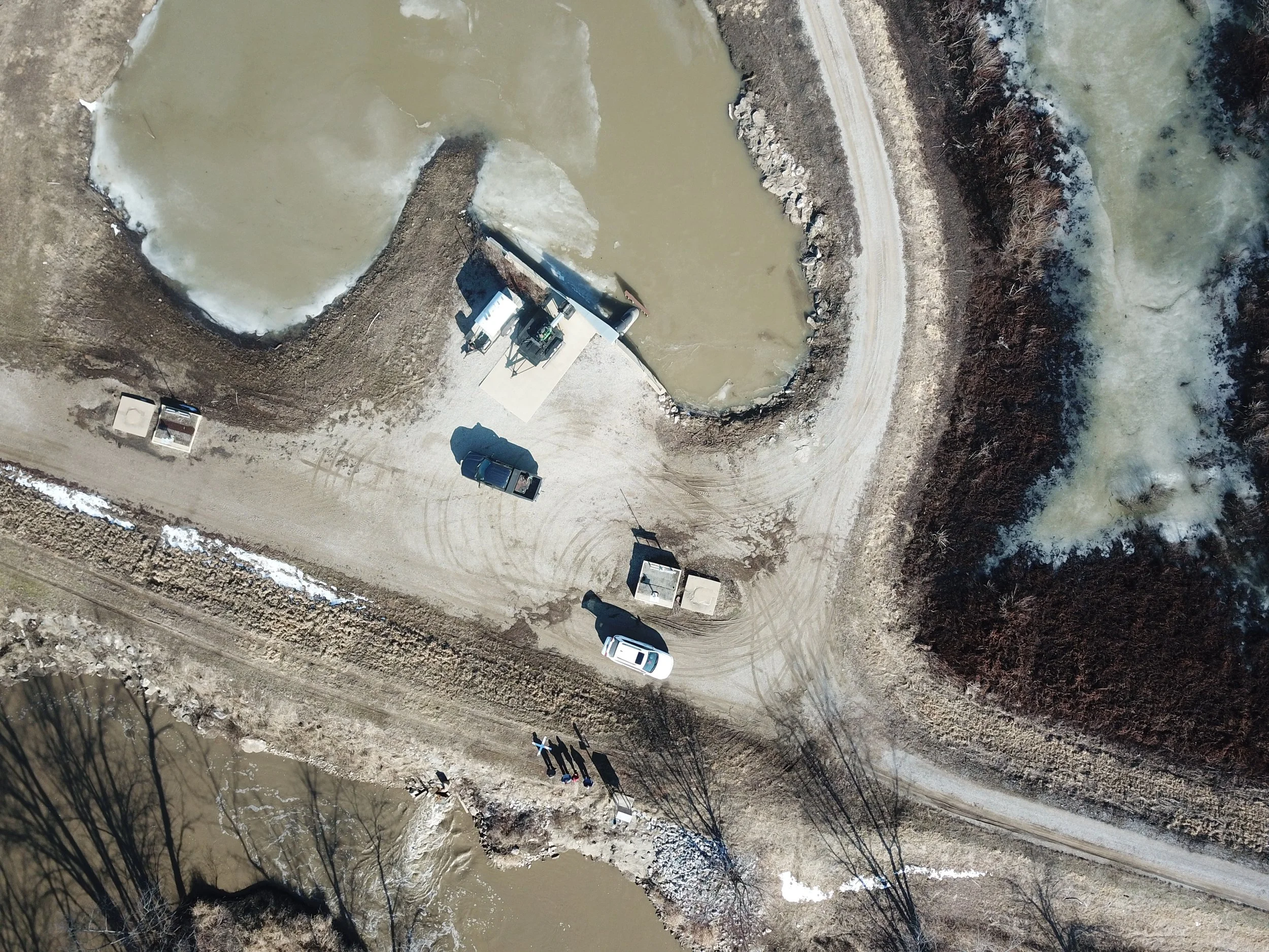
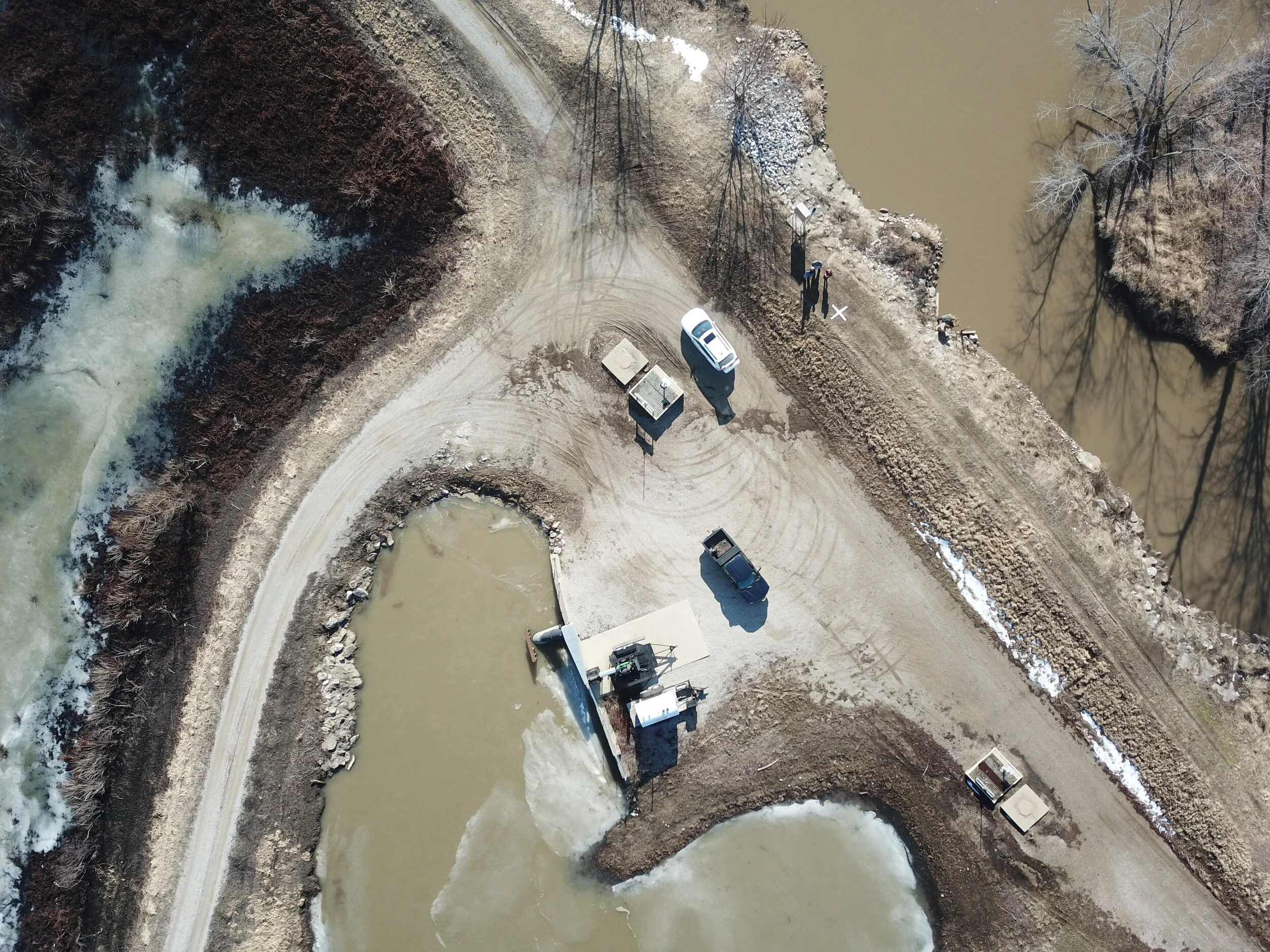
In an earlier post I shared some photos and insights into setting up Ground Control at Carlyle Lake for a LiDAR and Orthophoto collection flight for about a 40 square mile area. A Ground Control Survey, along with its associated targets, is what allows us to make sure the photos and LiDAR data we collect are aligned in the proper geographic location. We set up the Ground Control targets thinking we would fly the LiDAR and Orthophoto collection sometime in the following week, but we received so much snow and had such cold weather (25 straight days that never got above freezing) that we actually had to wait a month for the snow to melt and the water levels to lower back down to the winter pool level. That winter pool water level will allow us to collect LiDAR in most of the ditches and wetlands areas surrounded by levees. As you can see from the above photo, even a month later, after a week of 60 degree weather, there was still snow and ice in large portions of the wetland. Illinois can get very wet in March and April and every spring we run the risk of heavy flooding, so we had a break in the weather and a window of opportunity this week to fly the LiDAR and Orthophotos and we thought we needed to take advantage of the good weather.
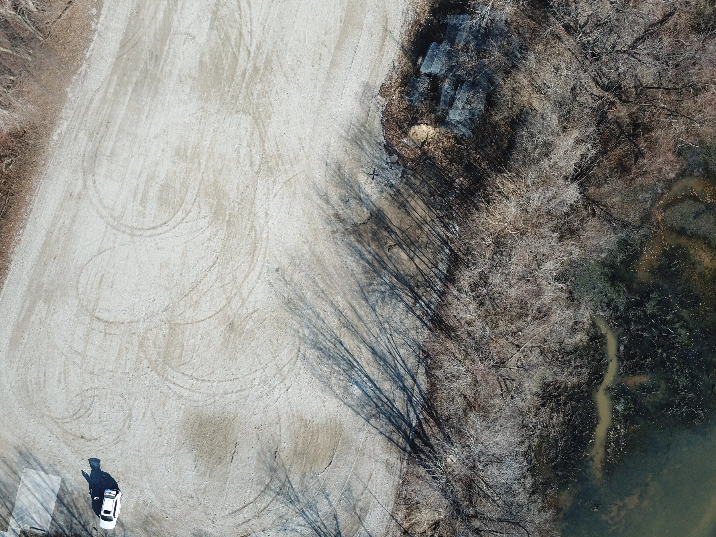
After a month of snow and ice we decided to check the Ground Control targets to make sure they were still in good shape for the collection. After being covered with snow and in a few cases flooding water, we thought it would be a good idea to check every one of them. The problem is that the area has been so wet that we did not think we could get to some of the targets we had access to when we set them when the ground was frozen. We made the decision to do drive by checks for the targets on hard surfaced roads and parking lots and to take a series of 5 preplanned automonous flights with our Unmanned Aerial System (UAS, or drone). For this flight we used our 5 year old DJI Mavic Pro drone with the DJI Go 4 App coupled with mission planning software called DroneLink. We downloaded DroneLink, did a few test flights in the office parking lot and headed off to Carlyle Lake to take try to photograph the Ground Control targets and give us some reassurance that they were still usable.
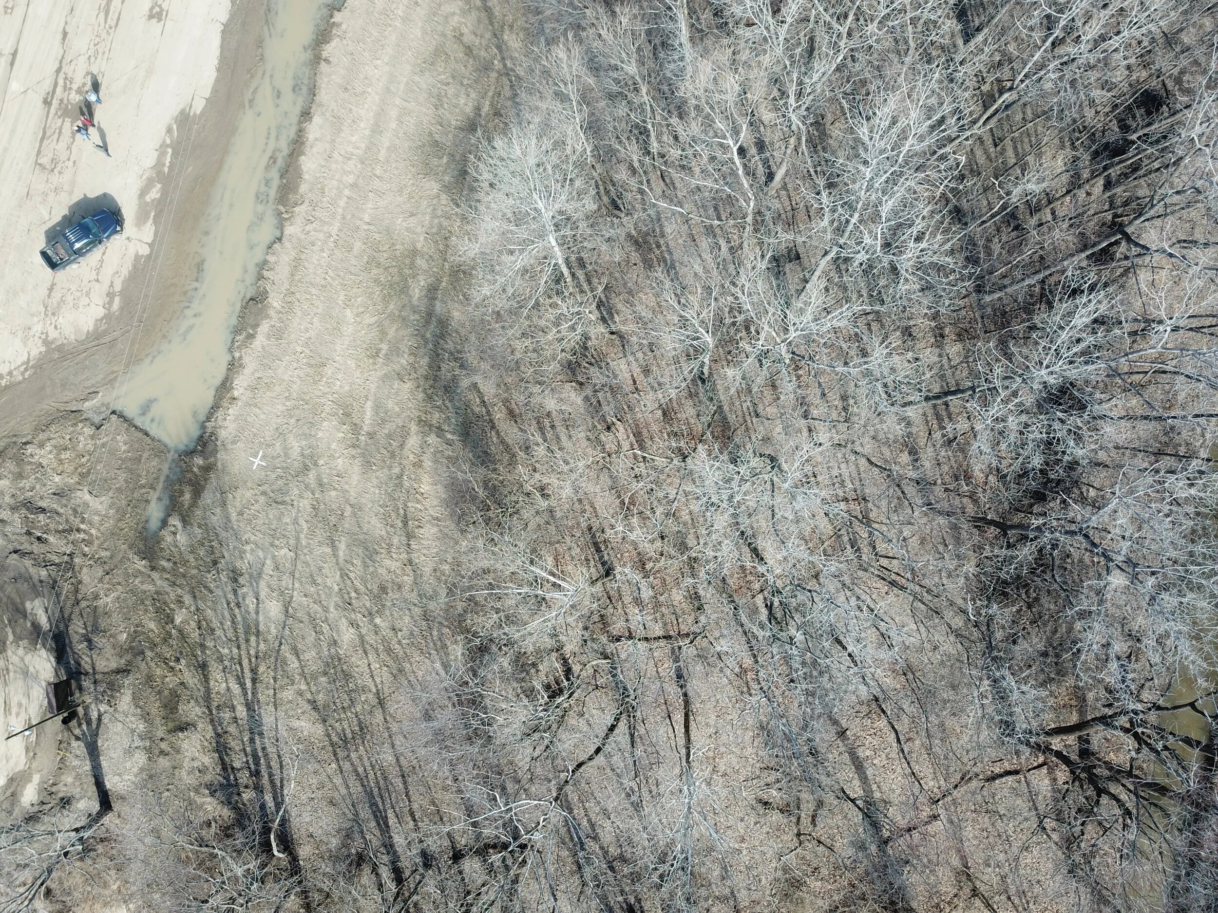
The Mavic Pro is old in drone technology years, but worked like a champ. It gave us the needed 20-30 minute flight duration for each of our photo missions. The above photo is one of the first photos we took before the autonomous mission as a test photo before going out on the mission. The Ground Control target is the black “X” in the upper center section of the photo. The Mavic took this photo from approximately 250 feet Above Ground Level. Most of our targets were white, but this one was against a light colored background, so we used a black target for this Control Point. All of these targets were surveyed with a better than 5 cm survey grade accuracy.
This is another target we could drive to. It is near a pumping station at the center of our wetlands project. You can see the white target on top of the levee in the upper center area of the photo. These two photos showed us what the Mavic could do and that we could use it to capture photos of targets that were inaccessible due to mud and ice.

The above is a photo of a target that wasn’t very accessible. You can faintly make out the white “X” near the center of the photo. We couldn’t get close enough to it on the ground to observe it, but the Mavic captured the photo and reassured us that the target was still there unharmed.

The above Ground Control target was in a very muddy area behind a locked gate. The Mavic picked it up well
The above target, located in the left center section of the photo, is a good demonstration of how valuable the Mavic was. Until the day before we shot this photo the target was under water. We were only about 50 feet away from the target, but we could not get to it because the ground was so muddy. The truck is parked on a hard packed parking lot, but the rest of the area is inaccessible.

In this final example you can see the target just to the left of the levee intersection. This is a great photo to show the value of the UAS. We were only about 1/4 mile away, with the UAS in full visual contact, but the levee roads were too muddy to get any closer to the target. The UAS is the only way we could have checked on the condition of the target without either risking damage to our vehicle or ourselves. With the effort of a 5 minute round trip flight we were able to assess the condition of the target and assure ourselves that the targets we placed in this small area were still usable.
Out of the 40 Ground Control Survey targets we set up a month ago, we were only able to do a drive by check on about 10 of them. We were able to set up our UAS operations in areas where we could visually watch the UAS fly from target to target while we managed the flight and captured the photos. We were able to check on the condition of all 40 targets in about 5 hours. The UAS saved us an estimated 2 days of work slogging around in mud, ice, and water. It was well worth our time and effort.
Greers Ferry Lake Survey Points
I wanted to share the map we created of Greers Ferry Lake. It is an incredibly beautiful place. It is probably one of the most picturesque places I have worked. The terrain was rough, but this made for beautiful cliffs and crystal clear water. On this map the red dots indicate the missing monuments that we either had to find or re-set around the lake. The green dots are the other monuments we used to help us find the missing monuments. It was a very busy, but rewarding time. Please click on the image below to go to our interactive map of Greers Ferry Lake.

Greers Ferry Lake, Cleburne County Arkansas, Surveying Monuments
Setting Ground Control at Carlyle Lake State Fish and Wildlife Area

South End of the Carlyle Lake State Fish and Wildlife area along the Kaskaskia River
VerticalGeo spent 3 days in January setting up Ground Control Targets for our upcoming Carlyle Lake LiDAR and Orthophotography project. The weather was horrid and after we set up the Ground Control the snow got worse. It is hard to believe the amount of water on the ground in the Fish and Wildlife Area on the north side of Carlyle Lake.

Setting out on a levee to set Ground Control at the beginning of the project. This is the best weather we encountered for the 3 days of setting out Ground Control Targets
We moved along the levee system setting up targets for our mission

CP8 near a pump station at the south end of the Fish and Wildlife Area
About an hour after we started it began to snow heavily.

It got worse throughout the day

Control Point 10 at the Eckert Access Parking Lot
Finally at the end of the day we had set out 40 targets and we completed our project.

Final point of the day at the Patoka Access Parking Lot. Then a nice, warm drive home
Surveying at Greers Ferry Lake: Part 2
We took a second trip in the middle of December to Greers Ferry Lake to finish up our surveying task for the Corps of Engineers. This was a very interesting project to locate and rehabilitate or reset lost survey monuments. I think Greers Ferry Lake is the most picturesque lake in all of Arkansas. It has been a interesting and rewarding project. I mentioned before how physically demanding it is to survey in this rugged terrain. The jagged limestone and granite outcrops have made for hard work. We finished locating or resetting the remaining missing monuments. Here are some photos of work during the second trip to Greers Ferry Lake.

Photo from a cliff overlooking a boat slip. The survey monument was located embedded in the rocks here. Youcan see the sheer cliffs on the other side of the water

One of the missing survey monuments was located next to this boat slip under 3 feet of water. The house above this boat slip has party lights marking the edge of the cliff in the back yard.

Another missing monument was located in the middle of this creekbed. This is an incredible place!

The monuments should be marked with a collar of white painted rocks and a T-Post marking the position. This one had the paint, but the monument was no where to be found, so we reset this one.

Greers Ferry Lake is an amazing place, even when it is brown in the middle of December. Imagine how beautiful this would be in the spring and summer when everything is green.
Surveying at Greers Ferry Lake: Part 1
We spent the last week working on a Corps of Engineers project locating lost survey monuments at Greers Ferry Lake near Heber Spring, Arkansas. It has been a very rewarding project, but also very physically demanding. The terrain has been difficult and the limestone and granite rocks have made this work a challenge. But, we have found several previously missing survey monuments that have helped the Corps of Engineers maintain their property boundaries. Here are a few photos of this beautiful area


The Slowdown in the Geospatial Intelligence Industry

I guess this is one of the reasons work has been slow lately. Link
Trinidad and Tobago Road Networks

VerticalGeo just finished updating our Trinidad and Tobago Road Networks. We have the updated map posted on our web-mapping portal. Here is the Link.
Ecuador Road Networks
We just updated our Ecuador Road Networks map and posted it to our web mapping portal at maps.verticalgeo.com

VerticalGeo creates, maintains, and integrates geospatial data for our customers
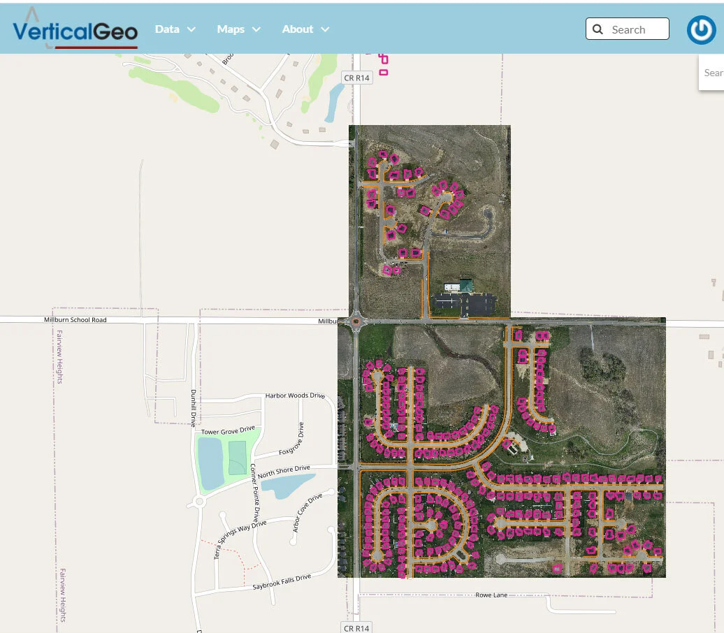
For many years VerticalGeo has been working with our home city, the City of O’Fallon, Illinois, to find the most cost effective way to deliver quality neighborhood data rapidly to the city planners. In March 2020 we started using our Black Swift Technologies S-1 drone with integrated RTK GPS correction to collect orthophotography of selected O’Fallon nieghborhoods from which we collected building footprint and sidewalk features to update the City of O’Fallon’s geodatabase. We were able to provide the aerial orthophotography and building footprint and sidewalk data for 7 separate rapidly growing neighborhoods within two weeks. Normally it takes several months for the city just to receive orthophotography. Two of the neighborhoods are highlighted in the below VerticalGeo Web Map. Click on the image below to go to the associated interactive web-map on the VerticalGeo Web Mapping site.
Caribbean Road Networks
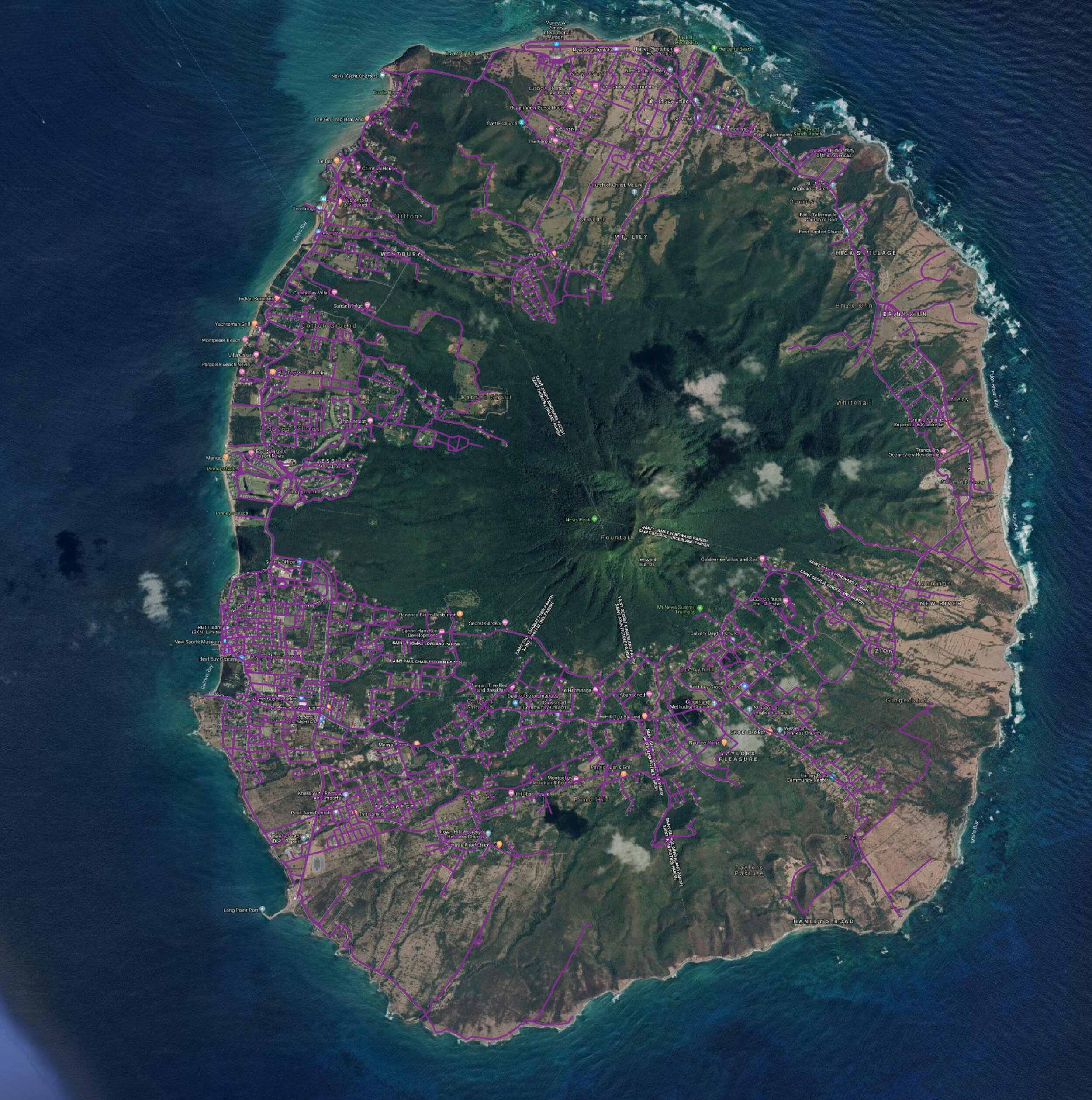
Nevis Road Network 2019

Charlestown Nevis Road Network 2019
VerticalGeo spent time this past summer creating road networks for most of the islands in the Caribbean. The screenshots below came from our St Kitts and Nevis Road Network Update Map. You can view our work there on the simple webmap we have posted online. Every year the islands in the Caribbean get slammed with hurricanes and need humanitarian aid to help overcome the disaster. The people of the Caribbean are very resourceful and resilient, and we decided that we could help them by providing updated road network maps. We started with satellite imagery and began with Open Street Map files of the entire Caribbean. We then took these Open Street Map files and used them to show us where the existing road networks were at. When we came across Open Street Map files that weren't accurate we updated them. When we came across areas where we saw road networks on the satellite imagery, but no roads documented in Open Street Map, we added the roads. When we came across roads documented in Open Street Map that we did not find on satellite imagery we deleted them from our Open Street Map files. In the screenshot below the purple roads are the road network we created for the country of Nevis. Here is a close up of the road network of the town of Charlestown in Nevis. We have completed road network mapping for the following countries:
Anguilla
Antigua
Barbados
Barbuda
Bolivia
British Virgin Islands
Cayman Islands
Colombia
Cuba
Dominica
Ecuador
French Guiana
Grenada
Guyana
Malawi
Mozambique
Paraguay
Saint Barthelemy
Saint Martin
St Kitts and Nevis
St Lucia
St Vincent and the Grenadines
Trinidad and Tobago
US Virgin Islands
We see this as an opportunity to help out the international disaster relief organizations that need data like this to help plan relief efforts around the world.