
VerticalGeo creates, maintains, and integrates geospatial data for our customers
For many years VerticalGeo has been working with our home city, the City of O’Fallon, Illinois, to find the most cost effective way to deliver quality neighborhood data rapidly to the city planners. In March 2020 we started using our Black Swift Technologies S-1 drone with integrated RTK GPS correction to collect orthophotography of selected O’Fallon nieghborhoods from which we collected building footprint and sidewalk features to update the City of O’Fallon’s geodatabase. We were able to provide the aerial orthophotography and building footprint and sidewalk data for 7 separate rapidly growing neighborhoods within two weeks. Normally it takes several months for the city just to receive orthophotography. Two of the neighborhoods are highlighted in the below VerticalGeo Web Map. Click on the image below to go to the associated interactive web-map on the VerticalGeo Web Mapping site.

VerticalGeo’s web-based mapping portal is located at http://maps.verticalgeo.com/. Please feel welcome to go there and view a few of our online maps.
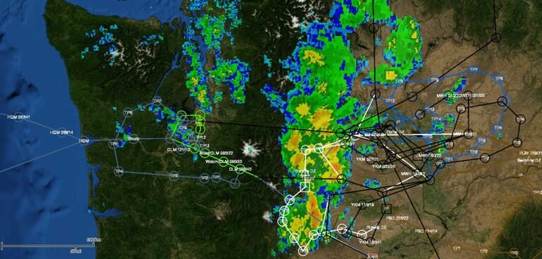
Above and below are screenshots of the web based mapping viewer integration platform we created for the US Air Force’s Air Mobility Rodeo. We mapped all the flying routes and added a live NextRad weather map overlay on top of an interactive physical terrain map to help provide situational awareness for the Air Mobility Rodeo Senior Leaders to make daily competition decisions.

Here is a small portion of the Air Mobility Rodeo parking plan that VerticalGeo created to help manage parking over 130 aircraft from 30 different countries on one airfield. Operations, Maintenance, Aerial Port, and Mission Support representatives used our Situational Awareness Viewer to make their support more effective.